2. INTRODUCTION
In creating graphics for the blind one has to take into account that the
fingers' discerning ability is so much less than the eyes', that in most
cases magnification will be necessary; and of course text in and around
the drawings will have to be put into braille; but I think most graphic
material will need more editing to make sense to the blind reader.
One might argue that editing is wrong, that the blind ought to be taught
reading graphics that are basically the same as in inkprint; maybe
there's a point in this, it's paternalistic,
but I'm afraid extensive editing is often the only way
of rendering a figure meaningful to the vision impaired.
Some of the other editing is a choice, because I
think it's best to do a drawing this way.
For instance, while the seeing person will generally have an overview of a
picture at first glance, the blind reader has to go through most of the
details in a picture to understand what it's all about: so adding
a good title to a drawing is absolutely essential, as a surrogate for
this overview-at-first-glance.
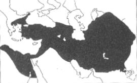
Point out King Darius' heartland
|
As another example, look at this historical map. There are no names,
but the sighted reader will
most likely recognize the area,
and that will bring to mind other maps and data of the area
that he or she has seen in the past;
but to the blind
reader it's most likely just a blur with some lines and dots.
I think we have to
provide the information that's not obvious to the
blind, but that's taken for granted
by the mapmakers for the sighted.
So I have added a map 'Present-day Countries' in the same outlines,
and I have identified some of the surrounding areas in the original map.
|
- orientation map:
Present-day Countries (ca 80K)
- the historical map
(ca 90K)
I thank my former and present department heads, Mr Leon Knierum and Mr
Herman Philipsen, and my former and present immediate superiors, Mrs
Nieuwpoort, Mr Van den Assem and Ms Hélène Vos, for putting
and keeping me in this position and allowing me time to think and write
about the development of the field; and I thank the members of my staff,
especially Marlon Macville, Walter Smekens and Leen Verkijk for their
examples and instructive mistakes.
One of the ideas on maps I got from from Colin McEvedy's beautiful historical
atlases (Penguin); some inkprint graphs etc. were taken from The
Economist.
go to first page, previous
page or next page
© 1989, 2002 Marco Schuffelen All rights reserved
Questions? Comments? email
me
Last modified: Thu May 15 10:25:17 PDT 1989